Interactive Metro Map with All Stations
The Surat Metro network spans 40.35 km with 38 stations across two corridors. The Red Line runs 21.61 km north-south from Sarthana to Dream City, including a 6.47 km underground tunnel. The Green Line covers 18.74 km east-west from Bhesan to Saroli, entirely elevated. Both lines connect at Majura Gate.
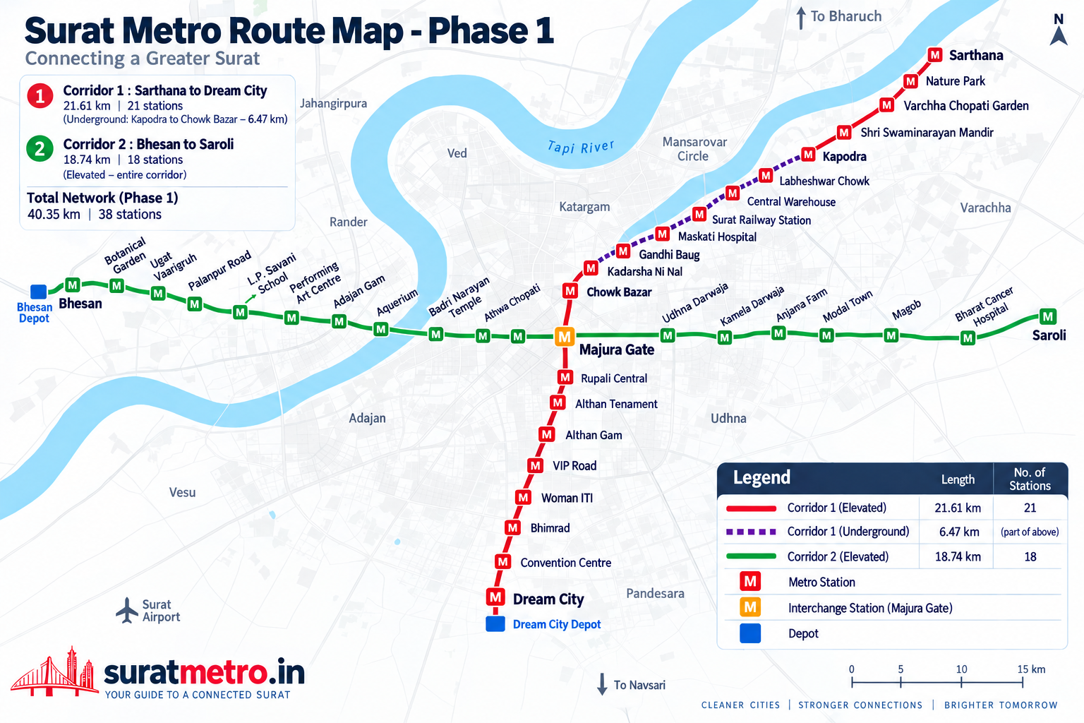
All Stations by Line
Full station directoryRed Line - Sarthana to Dream City
21.61 km | 21 stations | 6 underground
Green Line - Bhesan to Saroli
18.74 km | 18 stations | All elevated
Network Overview
Total length
40.35 km
33.88 km elevated + 6.47 km underground
Total stations
38
32 elevated + 6 underground
Corridors
2
Red Line (N-S) + Green Line (E-W)
Interchange
1
Majura Gate connects both lines
Explore More
All Stations
Browse all 38 stations with area guides and connectivity details
Route Planner
Plan your journey between any two stations on the network
Red Line
Sarthana to Dream City - 21.61 km, 21 stations, 6 underground
Green Line
Bhesan to Saroli - 18.74 km, 18 elevated stations
Nearest Station
Find the closest Surat Metro station to your location
Map and Route Questions
How many stations appear on the Surat Metro map?
The map shows all 38 unique stations across both corridors, plus a second marker at Majura Gate for the Green Line platform. The Red Line runs 21 stations from Sarthana to Dream City (21.61 km), and the Green Line covers 18 stations from Bhesan to Saroli (18.74 km). Majura Gate appears as the single interchange point where both lines meet.
Which Surat Metro stations are underground?
Six stations on the Red Line run underground through a 6.47 km tunnel between Kapodra and Chowk Bazar. These are Labheshwar Chowk, Central Warehouse, Surat Railway Station, Maskati Hospital, Gandhi Baug, and Chowk Bazar. The tunnel section was built using three TBMs named Amrit, Narmada, and Tapi. All Green Line stations are elevated.
Can I download the Surat Metro route map as a PDF?
Yes. Both PDF and high-resolution PNG downloads are available on this page. The PDF version is print-ready at 209 KB, and the PNG works well for sharing or setting as a reference image. Both formats show all 38 stations across the Red and Green Lines, the 6.47 km underground section between Kapodra and Chowk Bazar, depot locations at Dream City and Bhesan, and key Surat landmarks.
Where does the Red Line and Green Line interchange on the map?
Majura Gate is the only interchange station on the entire Surat Metro network. It sits at the intersection of both corridors, roughly in the geographic center of the network. Transferring between lines takes about 3-5 minutes including walking between platforms. Every cross-line journey passes through this station.
Can I switch to satellite view on the map?
Yes. Click the Satellite button in the controls bar above the map to switch from the street map to Esri satellite imagery with place labels. This helps you spot actual construction sites, elevated viaducts, and station structures from aerial photos. Click Map to switch back to the street view.
Does the Surat Metro map show real station locations?
Station markers on this map are positioned based on coordinates cross-referenced between OpenStreetMap data and Google Maps satellite imagery of confirmed construction sites. The track alignment shown follows the official GMRC corridor geometry. Final platform entries may shift by 50-100 meters from these positions once GMRC publishes exact coordinates.
Station positions based on OpenStreetMap data and Google Maps cross-reference of GMRC construction sites. Corridor alignment from GMRC official route map.